
Adamello Ultra Trail is the only Trail running event in the World that retraces the paths and mule tracks of the First World War. Along the historical trenches crossed more than a century ago by young soldiers, the athletes of Adamello Ultra Trail engage a sport challenge to overcome their limits and their endurance. The charm of this event is also to unite sport and the promotion of the territory and its history
The presentations of these sites of historical interests along the Adamello Ultra Trail’s route have been realized by Walter Belotti, President of the White War Museum in Temù
The Bocchetta di Val Massa, is a land dip located between Cima Bleis di Somalbosco and the left dorsal of the Eastern peak of Mount Coleazzo. It was the point that the military commands, fortified as the back line of the Italian defensive system, also because it was a dominant point on the Gavia road From there, on the left, representing one of the most beautiful examples of military architecture of the entire frontal territory, a series of trenches about one kilometer long depart. More than one hundred years later – in fact, they were built even before the war began – they are still preserved in a truly impeccable way, also because during the conflict they were never affected by war events and only a few sentries were guarding the area.
The defensive structure consists in above ground trenches and paths, made of local schistose stones with their typical rust color. Particular attention was also paid when placing the stones on the exposed side, in most cases, perfectly squared. This was possible thanks to the remarkable ability of the expert workers in choosing each stone and in the right placement of the same with a perfect static concept.
More than the defensive wall, following the almost thousand meters of the barricade it is possible to admire many peculiar architectural elements,
such as the loopholes for the firing of the riflemen, or the ones for machine-guns with their trapezoidal shape.


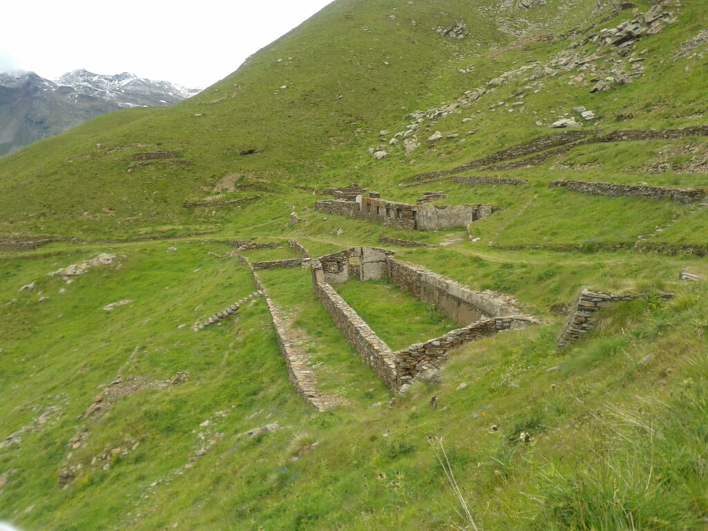
The Cima Rovaia (Rovaia Peak) was reachable by a military mule track starting from Pil, in Val Grande, and climbing up to Plazza Grande before continuing along the crest, which divided the Valletta Tremonti from Plazza Grande itself.
Here, more than Cima Rovaia, we can find the slopes of Cima Mattaciul. From Plazza Grande, the whole ridge leading to the Rovaia peak was set for the defense with trenches, artillery installations, caves and barracks for the troops.
Around the mountain-top, 22 round emplacements for riflemen and machine guns are still visible and well preserved, and their architectural features can be found in the barricade in Vezza d’Oglio


All artifacts were made as dry masonry, using local schistose and rust color stones, easy to use thanks to their versatility
Having these materials already on site, helped to insert the manufactures in the surrounding nature.
The wise placement of the stones, the method of working them and the architectural complexity still give tribute to those who built them.
In addition, thanks to the maintenance by the Stelvio National Park, these structures enhanced even further their value.
Also known as Forte Tonale (Tonale Fort), it was built between 1912 and 1915 at an altitude of 2,116 m, at the end of the arboreal vegetation, in a dominant position on the slopes of Mount Tonale Orientale.
Made of steel and concrete, accordingly to the latest innovations in military fortifications, back then it represented the most modern military work of the Austrian defensive system in the area. Its equipment consisted in 6 revolving domes, each of them armed with a 10 cm howitzer, as well as two observation domes and numerous machine-gun loopholes. The western side, where the opponents could have broken through, was sheltered by a ditch and fortified by a massive protective wall. It was part of the five forts located at the bottom of the valley, arranged according to the “pincer” scheme on the opposite slopes of the Val di Sole. Lower down, in fact, there were Fort Mero, Fort Strino, Fort Velon and, facing them, Fort Presanella or Pozzi Alti.

The Rifugio Bozzi (Bozzi Shelter) is located in the Conca Montozzo and was built as small barrack by the Regia Guardia di Finanza in 1910, to keep control of the Forcellina di Montozzo and of the Passo dei Contrabbandieri. In fact, this area was the alternative way to the Tonale Pass for both Italian and Austro-Hungarians, and a transit place for shepherds, hunters and smugglers.
A few months before the war, this small barrack stepped up from check-point to headquarters of the Regia Guardia di Finanza first, and as detachment later. Men were lodged in tents, built on the terraces realized in the hollow below the command barracks; later on, during the summer 1915, many other structures were completed, such as shelters and weapons’ deposits.
At the same time, first line defensive constructions were being built on all the surrounding ridges, from Ercavallo to Montozzo, Albiolo, Cima Casaiole, Monte Tonale Occidentale up to Cima Le Sorti. Digging activities were also ongoing: covered trenches, tunnels, shelters, caves for the troops’ recovery with ways out on the Val Montozzo,
where artillery tools were placed in order to hit Austrian positions, such as Comiciolo, on the Redival and on the entire ridge up to the Torrione d’Albiolo. Defensive structures were built even in the military village of the Montozzo detachment, with a special trench reaching the Punta di Montozzo, provided in its inner part of a 50 cm step able to let defenders shoot and at the same time to let other soldier get protection in the deeper part.

Later, antisplinters and antishrapnell spurs were built, in order to minimize the damages of explosions inside the trench. At the end of this trench, three open-air emplacements, linked to each other thanks to a path fully dug out of the ground and covered by stones and plants,
were realized to contain as many artillery pieces as possible;
here the main weapons were 149 mm mortars, perfect for this scenery due to their curved shot. Supplying were possible thanks to the enlarging of the near mule track that from Case di Viso climbed up to the Conca di Montozzo and the building of two cableways,
also used to refuel the first line on the Cresta di Montozzo. Large-caliber howitzers of 210 and 280 mm were also placed at the bottom of the Val di Viso and near the Malga Forgnuncolo.
Once completed the fortification works, some paths were transformed into mule tracks such as the one that from Conca Montozzo leads to the Ercavallo Lakes and the one that, again from Montozzo, leads to Dosso di Meda with a branch to Cima Le Sorti and Ponte di Legno, passing through Plassola.
Il Passo dei Contrabbandieri (Smugglers’ Pass) is located on the ridge between Val di Viso and the saddle of Tonale. A strategic point that allowed the Italian soldiers to access it from the Conca Montozzo through a comfortable military mule track without being subjected to the Austrian artillery fire and to overlook the Tonale Pass.
From here, the path spread out along the steep walls of Punta d’Albiolo, reaching the homonymous peak and the nearby Cima dell’Albiolino on one side, while on the other side, following a long entrenchment path, it reached first Cima delle Casaiole, then Monte Tonale Occidentale, Cima Bleis and Cima Le Sorti, forming the most advanced line of the Italian defensive formation on the Tonale front.

The military structure of this section of the front was all based on the accesses from Val di Viso, since it was impossible to reach these peaks around 2600/2700 meters of altitude from the saddle of Tonale, since this was controlled and kept under fire by the Austrians through their lines on TonaleOrientale and Monticelli.
For this reason, roads, mule tracks and entrenchment paths had been built on the Viso side of the mountain, which should have made it easy to reach all the most advanced positions distributed along the ridge. A powerful lighthouse had been placed at an altitude of 2815 meters on the crest that from Passo dei Contrabbandieri rises to Punta d’Albiolo, to control the underlying Val d’Albiolo.

The long ridge that from Torrione d’Albiolo slopes down to Monte Tonale Orientale (Eastern Mount Tonale) was the most advanced Austrian defense line on the orographic left side of Val di Sole On the mountain-top, the only evidence of the Emperor’s soldiers’ presence is a crumbling machine gun emplacement. From the top, a long entrenchment path connected all the various defensive structures that had been set up to face the opposing Italian lines.
This advanced line was supplied through a military road that went through the Strino Valley and that, once reached the Malga Strino, branched off in a radial pattern with mule tracks and trails towards the various artillery and bomb-throwing positions scattered along the mountain ridge that from Monte Tonale Orientale developed in a semicircle up to Monte Redival and Monte Mezzolo.
Moreover, the Saccarana Forts and the Mero Forts were connected to the main route of Val di Strino and were served by other roads that reached them directly from the underlying Passo del Tonale road.
At Corno d’Aola (Aola Horn) the impressive barrage of the Corno d’Aola Fort is no longer visible, while only a large wall, outside the fort itself, perpetuates its memory. The fort was situated at an altitude of 1.900, on Dosso Prepazzone, at the foot of the crest that rises towards the top of the Corno dell’Aola.. It was part of a group of 44 modern type forts, that were to be completed by the year 1913 along the entire Italian-Hasburg border.
The fortress was located in a dominant position on the overlooking saddle of Tonale, and therefore strategically important for the defense of the advanced Italian positions on the pass, where the first line of our defense system was attested. The modern Corno d’Aola Fort, equipped with 6 cannons in an armored dome, was the only Italian fortified defense that stood against the 5 Austrian forts placed just downstream of the pass. The fire main target of this project was in fact the control of the road coming from Vermiglio and of the Austrian forts of the Alta Val di Sole.
With this magnificent battery it was possible to strike the Austrian forts of Val Vermiglio that, not being equipped with range equal artillery pieces as the ones of the fort of Corno d’Aola, were not able to react adequately. On the right side of the fortress, towards the south, a long tunnel was built to host the ammunition deposit; from here the bullets and the launching charges were transported to the artillery pieces by special rail carts that ran along a narrow corridor across the whole upstream part of the fortified complex.
The building, disposed on three terraces, was so composed: on the north side, by the armored domes that housed the pieces, in the center the advanced part formed the guardhouse and on the south were the lodgings.

All around, the fort was equipped with iron fence, connected to the electricity, to protect against possible attacks of enemy troops and painted moss green to camouflage it in the surrounding environment and be less visible in case of air raids. In addition to the normal access through the military road, it was connected with the bottom of the valley by a cableway, about 2 kilometers long, which started from Castelpoggio (where today stands the Castle of Poia). Towards the end of September 1915, the cannons were removed because the intelligence learned of a possible bombing operation by the Austrians.
The guns that armed the fort were placed on the back of Dosso delle Pertiche, organizing a new battery that then developed effective activities. Wooden logs painted black were placed in the empty cannon housings, which, from a distance, gave the illusion that the fort was always functioning. Once the war was over, the fort became abandoned and only in 1927 it went back working The Ministry of Defense leased it to Comm. Emilio Antonioli from Manerbio, to build a summer camp for the employees of the Marzotto wool mill.
Always according to Comm. Antonioli’s will, in 1930, upstream of the fort, was built a small church with a structure almost entirely made of granite. On February 9 th, 1945, during the retreat of their troops, the Germans, in the event of the construction of a defensive line at Passo del Tonale, provided for the complete destruction of the fort, as they were afraid to leave an important stronghold in the hands of the enemy.
The little church had also been despoilt, mined and intended for demolition, but was spared thanks to a noble gesture by the German Catholic officer in charge of the operation. Today, more than 90 years after the construction of the only Italian fort in the Alta Valle Camonica, only a few ruins of the great wall facing Tonale remain, peaceful witnesses of the great battles of the White War.
The Piana dei Moréi-Cresta Salì fortified line was part of that complex of back lines that, from the mountains above Ponte di Legno, went as far as the mountains of Edolo, ending in the fortified works that cross-blocked the valley in the alluvial Greano Plain, in the Municipality of Sonico.
The positions of Pornina and Piana dei Morei were also connected, on the opposite side, to the entrenched lines of Cima Rovaia, Pianaccio and Mortirolo, forming with them the ‘Mortirolo barrage’.
These, however, were the rear lines of the front that, having a purely defensive purpose, were never affected by any warlike events, as were the other rear barrages. The circular posts for machine guns and riflemen, built on the Cresta Salì, reproduce the same building typology as those built along the fortified line of Cima Rovaia. These are military artefacts that can only be found in these two locations.
There is, however, a difference between the posts of Cresta Salì and those of Cima Rovaia; the first have their walls largely sticking out of the ground, while the second are completely underground.
Their circular structure does not clash with the environment in which they have been placed; on the contrary, it blends perfectly into it, creating a whole with nature.
The circular posts are made of schist stones arranged dry, i.e. without the use of binders.
The shooting post is formed by a circular arch masonry with an average height above ground of 1 metre, a diameter of 2 metres and a thickness of 50 centimetres.
The five posts were wisely distributed along the ridge line, taking advantage of particular conformations of the terrain, in a strategic position; in fact, from them one could directly overlook the road that climbed to the Tonale Pass and the outposts of the first line of the front.